Monaco bus system map
You can find on this page the Monaco buses map to print and to download in PDF. The Monaco bus system map and the Monaco trolley map present the network, stations and lines of the buses and trolley of Monaco in Monaco.
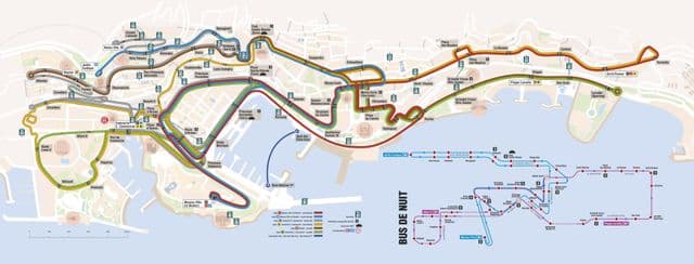
Monaco bus map
The Monaco bus map shows all the stations and lines of the Monaco bus system. This bus map of Monaco will allow you to easily plan your routes in the buses of Monaco in Monaco. The Monaco bus system map is downloadable in PDF, printable and free.
Monaco bus lines 1, 2, 4 and 6 are especially useful for visitors, along with the Bus de Nuit. Key stops are at place d’Armes, Monaco Ville and Monte-Carlo Tourisme as its mentioned in Monaco bus map. Line 1 links Monaco Ville (Le Rocher) to Monte Carlo and then continues east up bd des Moulins. Line 2 links Monaco Ville (Le Rocher) to Monte Carlo and then loops back to the Jardin Exotique.Line 3 links Fontvieille with Villa Paloma near the Jardin Exotique. Line 4 links the train station with the tourist office, the casino and Plage du Larvotto. Line 5 links the hospital with the tourist office, the casino and Plage du Larvotto. Line 6 links Fontvieille with the tourist office, the casino and Plage du Larvotto.